Navigation
Until the beginning of the sixteenth century, navigators had scant need to fix their precise position by latitude and longitude. Voyages were short and principally followed the coast; ships were rarely out of sight of land for more than a few hours' time. As voyaging increased into the uncharted regions of the open ocean, the navigator had to know his exact position at sea, and, its corollary, be able to return whence he started in order to bring back information about his discoveries.
The most basic method used by the navigator to plot the course on a chart is called "deduced" (or "dead") reckoning. Continuous records were made of the direction traveled, provided by the magnetic compass, and distance as the result of time elapsed the time elapsed (measured by a sand-glass) multiplied by speed. The course was calculated hourly. When conditions were right for taking celestial sightings, the dead reckoning course was updated and corrected.
Another method is known as "latitude sailing" or "running down your easting (or westing)." Once the navigator reached a desired latitude, which he determined by sightings of a celestial body (Sun or the Pole Star), he maintained his course on that latitude by sailing due east or west. This method required no elaborate tables of declination or complex mathematical calculations; all that was needed was to keep that celestial body at the same declination, its angular height above the horizon. Latitude sailing enabled the mariner to reach his objective without having to know the longitude--it was only necessary to keep sailing at the same latitude until the destination was reached. Christopher Columbus practiced latitude sailing on his 1492-1493 voyage, as did Vasco da Gama when he rounded Cape of Good Hope and reached Calicut, India in 1498.
Celestial navigation--determining one's position from observations of the sun or stars--provided greater flexibility. To the end of the fifteenth century, the celestial body most often used was Polaris, the North Star, for this was the easiest to use and required no tables of declination. At first, only the meridian altitude of Polaris was used--that point when it reached its zenith in the sky. Later, navigators were able to use Polaris at any time of the night without having to wait for it to reach its zenith. By the end of the fifteenth century, mariners could determine their latitude position from the sun as well as from the stars. And finally, with the development of the marine chronometer in 1761, navigators could also determine longitude. With a grid pattern to mark their position on the surface of the earth, and the means to plot a course, mariners confidently moved across the trackless, open ocean.
Boxed Compass
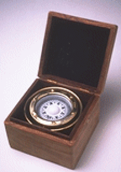
Magenetic Compass build by Dutch, 1571-1638 with Brass and Wood, 16 cm.By the fourteenth century, the eight primary points of the compass were sub-divided into sixteen and then thirty-two points; each point equally spaced at 11°15'. By the end of the sixteenth century, compass cards carried a dual system of points and degrees. Any good sailor could "box the compass," giving the name of each point in turn: north, north by east, north northeast, northeast by north, etc., until all thirty-two points were covered. This arrangement of compass points remained until the first half of the twentieth century when it was replaced with the degrees of a circle.
Sand-Glass
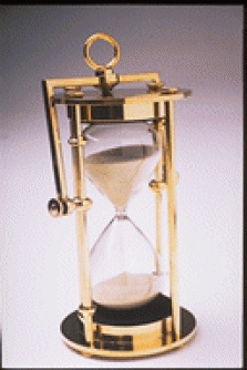
In navigating long distances across the open ocean, the sand-glass for making time was as important an instrument as the compass for showing direction. Filed with the amount of sand to measure a half hour of time, each emptying of the sand was called a "glass", and eight glasses (four hours) made up one "watch." The compass and sand-glass, along with a chip-log to measure speed, enabled the navigator to plot his ship's position on a chart. Speed times time gave the distance, and the compass showed the direction of the course sailed. This simple method of navigation is called dead-reckoning, short for deduced reckoning.
Astrolabe
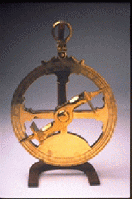
Astrolabe made up of Brass In the Middle Ages, the instrument used for measuring the angular height of a celestial body above the horizon was the planispheric astrolabe. This instrument adapted to one more suitable for "taking the height" while at sea--the nautical astrolabe. Consisting of a perforated disc made of bronze or brass, which gave it weight, the astrolabe was suspended from a ring at the top. Affixed to the center of the disc was a sighting bar called the alidade, which could be turned in a complete circle. The navigator aimed the alidade at the heavenly body, either the sun during the day or the pole star at night, aligning it by sighting through holes or notches in plates at each end. He read the altitude in degrees directly off a scale inscribed around the circumference of the disc.
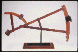
Cross-staff
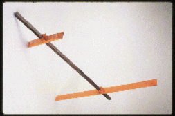
The cross-staff, originating sometime in the thirteenth or early part of the fourteenth century, Cross Staff made from Rosewood and Cherry was a better instrument for taking readings of the altitude of a celestial body than the quadrant or the astrolabe. The ultimate in simplicity, it was but a long stick with a movable cross-bar called the transversary. The navigator aimed the lower point of the cross-bar at the horizon and moved the cross-bar until its upper tip touched the celestial body; then he read the altitude on the scale inscribed along the length of the staff. To prevent painful damage to the eyes by having to look directly at the sun, a small shield blocked the sun (except its uppermost edge), and the navigator made a correction value to find the true reading. Alternatively, a small piece of smoked glass was used.
In spite of the knowledge of how to determine latitude by means of celestial observations, and the existence of nautical instruments to take these measurements, there was a vast difference between theory and practice. The instruments themselves caused a certain amount of error; with the astrolabe, this could be as great as one whole degree of arc, equal to an error of sixty nautical miles. It was no small feat for the navigator to keep the cross-staff aimed at the horizon, while at the same time moving the cross-bar so as to have its upper tip touch the celestial body, all the while trying to brace himself on the pitching and rolling deck of a ship. Under these conditions it was no easier to maintain a star or the sun in the sighting holes of the alidade of an astrolabe.
Back-staff
Backstaff (Davis Quadrant) made from Rosewood, Walnut and Mahogany Essentially, the Back-staff was a modification of the cross-staff, having a sliding half-transom in the form of an arc, and a horizon vane at its proximal end. Instead of looking directly at the sun, the observer turned his back toward the sun (hence the name back-staff) and moved a cross-piece along the arc. When the shadow cast by the sun was aligned with the horizon on the horizon vane, a reading was taken off a scale.This eliminated the problem caused by the cross-staff of having to look in two directions at the same time, as well as distortion and errors caused by irregularities in the glass. It also prevented temporary blindness by having to look directly at the sun.
The Octant
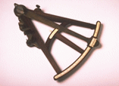
Octant (Hadley's Quadrant) madr from Rosewood with ivory scales and brass fittings 46.4 cm English, ca. 1780 The Use of a Mathematical Instrument Called a Quadrant 15.2cm x 9.9cm Obtaining measurements of the angular height of a celestial body above the horizon is not difficult, as attested to by the early development of the cross-staff, back-staff, and marine astrolabe. The real problem lies in being able to achieve this with great accuracy, and under the difficult conditions of being at sea on a small boat.
With the rise of exploration during the seventeenth century, maritime nations of the world encouraged the development of better navigational instruments. Voyages of increased distance and duration required being able to more correctly plot position at sea, and to locate newly discovered lands that they be accurately shown on maps. In 1731, John Hadley, an English astronomer, mathematician, and physicist invented the octant. He added to the simple quadrant, optics, and a reflecting mirror to bring a body in the heavens into coincidence with the horizon, thereby turning the quadrant into a reflecting telescope. At nearly the same time, in Philadelphia, Thomas Godfrey arrived at the same solution. This instrument, the octant, is the predecessor of out present-day sextant.
Profiles
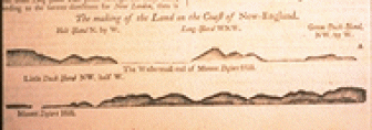
plan, or bird's-eye, views of land on nautical charts in pilot books were often accompanied by horizon profiles of the coast. These small scenes depicted the land as a mariner would see it when approaching from seaward, and aided him in identification to assure a proper landfall. In the centuries following their introduction they were sometimes elevated to exquisitely detailed landscape engravings or watercolor drawings, far surpassing in aesthetic appeal their original intended function
